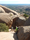
1) Navajo Loop & Queens Gardens - Bryce Canyon, Utah.
These two trails combine for a 3.6 mile roundtrip. The steep switchbacks down must also be used to come back up, but otherwise, it is an easy trail, with hundreds of gorgeous hoodoos formed from frost weathering and stream erosion through the millenia. Watch out for rattlesnakes.
2) Canyon Overlook Trail - Mt. Zion Nation Park, Utah.
I seem to remember this trails as being longer than its one mile roundtrip distance, but perhaps that is due to the need to proceed a bit more slowly than on easier trails with fewer narrow ledges, or because we were stopping a LOT for photos. This is a great trail that ought not to be skipped if you are ever in the area.
3) The Narrows (Bottom-up) - Mt. Zion National Park, Utah
To reach the Narrows from the main entrance, lodges and parking area, you have to access the Riverside Walk (2-mile roundtrip) on the "Bottom-Up" direction for this hike. The "Top-Down" version is a 16-mile (10-14 hour) hike that ought to be reserved for very fit, experienced hikers, who absolutely know when to abort a hike due to weather conditions. The Bottom-Up version takes approximately 2-3 hours to reach the most popular return point, known as "Wall Street." Sixty to Seventy % of the Narrows require you to wade through varying levels of a river flowing through the slot canyon. When I visited that river varied from ankle-deep sections, all the way up to chest-deep on me, or almost 5 feet of water (I am 6-feet in height). There was not much of a current, but a dry-bag and walking stick or poles come in very
handy, since the bottom rocks can be a little slippery, and you are bound to get soaked at some point. The slot canyon is impressively scenic, but also very dangerous, as heavy rainfalls can spring up from seemingly nowhere on a previously-cloudless day. Several hikers have lost theirs lives here in the past, by ignoring impending weather and suddenly being met with a flash flood speeding towards them.
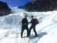
4) Fox Glacier Heli-hike - Westland Tai Poutini National Park, South Island, New Zealand.
It's hard to beat a hike that starts with a helicopter dropping you off at the top of a 8-mile (13km)-long glacier, then strapping on crampons, hiking on the ice for 3 hours, and sliding or wiggling through three or four ice caves, prior to the return helicopter trip. The blue ice and the towering, craggy surrounding cliffs, massive waterfall and seemingly-ou-of-place, adjoinning green rainforests made this one of the best hikes I could possibly imagine.
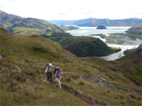
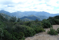
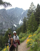
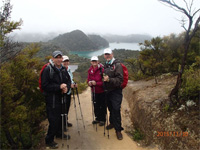
5) Rocky Mountain Track - Wanaka, New Zealand
The Rocky Mountain Track is approximatley a 3 to 4 hour hike, up and down, but it is steep, and has a noteworthy elevation gain. The draw is the great view at the top, both of the nearby snow-capped mountains and of the lakes below. There is a much shorter hike at the start that ends at Diamond Lake, but the young, and the physically-fit will be very glad they continued along the longer trail to the summit. Although I walk 5 miles almost every day, and do some stairmaster work, it was steep enough to fall at the outer bounds of my aerobic endurance abilities at age 63, but I was happy I did it.

6) Pöllatschlucht-Neuschwannstein-Marienbrüke-Hohenschwangau trail - Füssen, Bavaria, Germany.
This hike is approximately a 3-mile trek, with steepness from the town up to the Neuschwannsteain castle, and then again up to the overlook areas. The Allg u mountains provide a worthy German alpine backdrop, and the castles and Pöllat river gorges add additional highlights. It is about a 2-3 hour roundtrip hike.
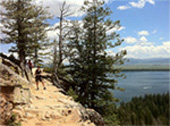
7) Hidden Falls and Inspiration Point trails - Jenny Lake district, Grand Teton National Park, Wyoming.
The Inspiration Point trail is reached at Hidden Falls, so these trails are really just a continuation of one another. Hidden falls is a 5-mile rountrip hike from the Jenny lake Visitors Center, and Inspiration Point adds another .9 mile for a 5.9 mile roundtrip hike. The scenery along the way is beautiful, the falls are great and the view from Inspiration Point is spectacular. It is a moderate hike for the young and for the physically-fit. Inspiration Point has some windy, narrow ledges, with loose footing that can make it very iffy for the elderly or those not used to hiking mountain trails.
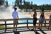
8) Fountain Paintpot Trail - Lower Geyser Basin, Yellowstone National Park, Wyoming,
Virtually everyone who visits Yellowstone visits Old Faithful, which is bound to be at least a half-mile from your lodge or parking spot, but
Fountain Paintpot Trail is something that you would need to have learned about in advance, or discover when seeking worthwhile hiking trails within Yellowstone.
Although the "trail" is only an easy 1/2 mile loop, completely flat, and has wooden decking around the geysers and paintpots, it is very much worth the time to see it.
9) Elk Mountain Trail - Wichita Mountain Wildlife Refuge, Oklahoma.
This is a 2.2-mile rountrip hike, but you should allow about 3 hours, because you will ceratinly want to spend some leisurely time at the top, moving from one summit over to another nearby one, and just soaking up the pretty amazing views from atop the numerous monolithic boulders. There are some steep areas and lots of rocky footing, so it is easy to slip, or roll an ankle. Because of the many large rocky surfaces and the location in southwestern Oklaohma, you need to be particular alert for rattlesnakes and copperheads.
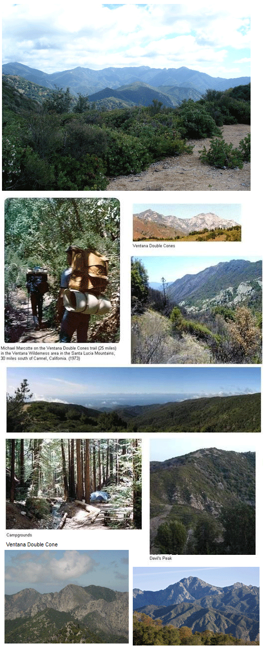
10) Bottcher's Gap to Double Cones trail, Ventana Wilderness, Santa Lucia Mountains.
Nearest city: Monterey. This is a 29.5 mile roundtrip hike. There is a campground near the Double Cones, so most hikers hike in on one day, and back out the following day. The terrain varies from forested areas, to grassy, Yucca-covered hillsides, and short but steep, rocky climbs (such as at Devil's Peak).
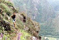
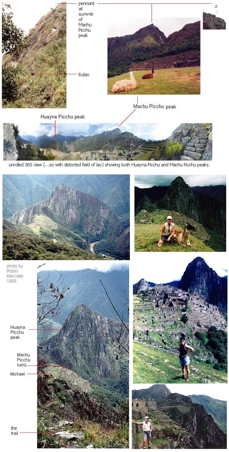
11) Machu Picchu Summit trail - Machu Picchu, Andes Mountains, Peru.
Height to climb from Machu Picchu ruins to the peak summit: 652 meters (2,139 feet). Terrain: Inca Trail stone path steps and in places grass/dirt.
It might read like this is not such a hard climb, but understand that you are starting at an elevation of 7,972 feet above sea leavel, and then climbing steeper steps than those in a normal house for yet another 2100 feet. It takes approximately 2 hours for the ascent, and 30-45 minutes coming down.
Try spending 2 hours on a stairmaster, and then add the elevation-gain fatigue and thinner air!
The view back down of the Inca ruins, the cloud forests, and of the Urubamba River are breathtaking. Many hikers prefer the Huana Picchu trail on the other adjoining peak from the ruins, but that trail was closed to us in 1999, due to a fire and collapsed trail.

12) Great Wall of China - Badaling, China.
Although you might not consider this a "real" hike, you should, and you certainly would if you had ever walked it! The uphill climb along the Great Wall section at Badlaing up to the Beibalou Point, at 3,330 ft above sea level, is a longer, harder hike than almost anyone expects. It is more difficult than many 5-mile trails, and more exhausting than even some 8-9 mile trails that I have done. There is even a Chinese proverb that says "You are not a real man until you haved climbed the Great Wall of China."
As you would expect, the views and the uniqueness of the trek are very worthwhile.
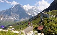
13) Kleine Scheidegg to Wengen or Grindelwald - mountain trail, Kleine Scheidegg, Switzerland.
I've only done this hike in summer, so I don't know if it is even possible at other times of the year. In June, the Edelweiss and other mountain flowers come out on the green-turfed slopes, and with the towering, encircling Swiss Alps, you might swear you had walked into a scene from "the Sound of Music" or "Heidi."
The hike to Grindelwald is about 3 hours, and since it is downhill, you are in luck; that's the best direction to climb a mountain! The stroll down is incredibly beautiful. Most people who do this hike have first been up, via the cog-wheel train, to Jungfraujoch.
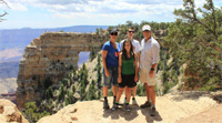
14) Cape Royal Trail - Grand Canyon, North Rim, Arizona.
Many of the trails we did at the Grand Canyon in 2011 were of the shorter variety, such as this one, which was only 1-mile roundtrip, and included the Angel's Window.
There were really no bad trails at either the South Rim or the North Rim, and all were easily reachable by car. We did something like 5-6 in all, but did not descend down into the Canyon, except on a smooth water raft trip down the Colorado.
15) Death Canyon Trail - Jackson Lake area, Grand Teton National Park, Wyoming.
The entire trail is 10.5 miles, but we elected to just go out approximate 2 miles and then retrace our way back, so as to have a 4-mile hike. Even so we
still saw a couple of deer, a moose, and a very fresh bear track. Bear bells and bear spray are both highly recommended in Grand Teton
National Park.
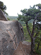
16) Beehive Trail - Acadia National Park, Maine
This trail is only two miles, roundtrip, but is listed as Acadia NP's most advanced trail. This is because the trail is steep, even vertical in some places, using iron rungs set into the granite face of the mountain.
There are other places where you have to do some light free-climbing, and there are others were only a 12-inch ledge is between you and a 200-foot or drop to jagged boulders below. It is not a hike to do in wet or icy weather, and I would advise against it in freezing temperatures, as you really need to be able to feel your hands and feet on this climb.
I did it alone, but in retrospect I would not do that again. It is short enough, but challenging enough that the combination of those attributes makes it a really fun trail. Nice view from the top, and an easier trail down.
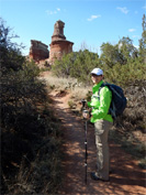
17) Lighthouse Trail - Palo Duro Canyon, Texas.
Amarillo is the nearest big city. There are numerous trails here, and we did about three, combined to ten miles, but the only one I would really care to repeat is the Lighthouse trail.
The Lighthouse trail is 5.75 miles roundtrip, mostly flat until the final approach to the Lighthouse hoodoo. The hike offers interesting sights along the way, but that last, steeper part near the Lighthouse was really fun.
The Lighthouse hoodoo itself can be scaled, and many do so, but the view from its platform is plenty satifying, and certainly the right spot for a selfie!

18) Ocean Path - Acadia National Park, Maine.
Not to be confused with the quaint "Ocean Trail" harbor-side sidewalk in nearby Bar Harbor, Ocean Path is a is 4-mile, oceanside trail along the beautifully-rocky Atlantic coast of Maine, that may well be the shortest 4 miles I've ever done, due its the distractingly-photogenic nature.
It is listed as moderately difficult, but aside from slipping once or twice on damp, slightly-moss cover rock, I'd say it should be categorized as easy, but slippery where wet. Otter Cliffs and Thunder Hole are two of the more popular landmarks along the trail, but I really
enjoyed the very numerous "intentional" sidetracks offered that lead closer to the shoreline (note: some of these do get very slippery).
Depending on how often you get sidetracked, you could probably add another mile or two to your hike, as did I. It was a very rainy and chilly day with rather foggy visibility when I visited, in September 2015, but I had precip pants and a raincoat that kept me dry, so I still managed to find it a really enjoyable hike!
19) Abel Tasman Coast Track - Marahau to Anchorage Bay, Abel Tasman National Park, New Zealand.
The entire Coast Track is 37 miles, one way. This portion of the hike is listed in some sites as 7.8 miles, but according to both the signs along the trail and my fitness tracker, this section was 16 km from where we started (We left the trail at 8.75 miles, but then backtracked on the beach .25 miles to meet a boat). The distance discrepancies may also be due to a couple of scenic detours town to the beach and back up or to our actual destination, past the Achorage Bay warming hut, then back to the hut.
We visted at the very end of November, and it rained the entirety of the nine miles. I enjoyed the variety of ferns, foxtail flowers and trees along the way, as well as some of the sea caves down on the beach, while the tide was out. I might have enjoyed it more in nicer weather, or for a slight shorter distance, but it was still a nice hike.
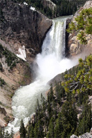
20) Brink of the Lower Falls - Yellowstone National Park, Wyoming
The trail down to the Lower Falls is only suposed to be 1/2 mile, down but it seemed much longer, probably due to the numerous switchbacks (although it is possible we kept going to Inspiration Point). It seeemed even longer back up, as it was moderately steep. There was a section of the trail where you could also get a distant view of the Upper Falls of the Yellowstone River.
The viewing point the Brink of the Lower Falls is certainly awe-inspiring, and well worth the hike. There are extensions to the trail that venture deeper into the wilderness. A pair of hikers
were mauled and killed by a grizzly bear with cubs on that extended section, within two hours of our own visit, that same day. The shoreter more direct section is likely continuously much safer due to a steady stream of dozens of vistors.
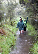
21) Nile River Trail and Caves - Charleston, New Zealand.
The trail to the caves passes through a forest, cliffs and across a swing bridge over New Zealand's Nile River. On the date we visited, it had rained for three days and the river was swollen, and the trail was knee-deep, submerged in water (...no snakes in New Zealnd, thankfully!). The hike through the cave was very nice, with numerous stalagtites, stalagmites and glow worms, but faitly treacherous due to low overhead in many places that caused everyone to proceed in a very crouched position, plus some very slippery footing that foiled two in our group of nine, leaving them with twisted knees, scrapes, and bruises.
We were unable to do the site's tube rafting due to the river levels and velocity, but the hike was still very good due to the size of the cave sections and the duration of the trek.
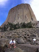
22) Tower Trail - Devil's Tower National Monument, Wyoming.
The loop around the base of Devil's Tower is only 1.6 miles and I suppose some might consider it a little boring, since the terrain and singular point of interest remain the same, throughout. I enjoyed it, regardless, as there were differnt surface features at the base or on the sides of the tower to draw my attention during this short hike, and since the Tower itself is so incredibly imposing.
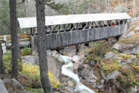
23) Flume Gorge - Lincoln, New Hampshire.
This trail is is 2-mile loop, with several covered bridges and a nice gorge and waterfall on the way up, and more forested terrain on the way down (unless you retarce your path up).
It can get a little crowded at the more photogenic spots, but is a nice short hike that I'd recommend, if in the area.
24) Peaks of Otter - Blue Ridge Parkway, Bedford, Virgina.
I only visited once, at about age 6, but it should speak volumes that, nearly 60 years later, I recall the visit well enough to include it in this list. The Sharp Top trail portion is 3.6 miles, rountrip up/down, and in my memory offered a trail along cascades, with panoramic views out across the Blue Ridge Mountains. I recall it as something like a longer version of New Hampshire's Flume Gorge trail, immediately above. Another trail (Flat Top) is 4.5 miles roundtrip.

25) Bison Trail - Wichita Mountain Wildlife Refuge, Oklahoma.
This trail is 5.7 miles roundtrip, and crosses through diverse varieties of grassland and rocky knolls, meadows, cliffs and valleys. Depending on the dtae of the visit, you might see abny number of wildflowers, and free-ranging bison or Texas Longhorn cattle, white tail or mule deer, Oklahoma Collared Lizards (Mountain Boomers), and possible a rattlesnake or two.
It is a nice hike with moderate steepness in parts, but also some extended portions with awkward, heavily-stoned footing.
26) Humpback Rocks - Blue Ridge Parkway, Virgina
There are more than one trail that ascend to the Humpback Rocks, and I have done two of those, but most people access the trailhead from the Humpback Rocks Parking Area at MP^ on the Blue Ridge Parkway. That trail proceeds as a one-mile ascent, rated as very tough, due to the steepness. The other one is even tougher in my opinion, but it may be that we actually LOST the real trail, as it seemd at times that we were just grabbing
whatever brush lay within reach to haul ourselves up an annoyingly-steep face of the mountain.
The rocks at the top project out imposingly, offering a tremendous panoramic view of the Shenadoah Valley, and everyone I have been there with was suitably impressed with that view.
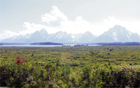
27) Christian Pond Trail - Jackson Lake Lodge, Grand Teton National Park, Wyoming.
This trail is only 1-mile roundtrip, and starts just to one side of the Jackson Lake Lodge. The trail proceeds up a hill among a seemingly-endless variety of wildflowers, overlooking the very scenic Jackson Lake, Elk Island, and jaw-dropping spendor of the Grand Teton mountain range.
The hike can be extended to a 4 miles by circumnaviagting the pond, but extra special care should be takem, as the area is frequently posted as off-limits or discouraged due to seasonally-recurring, extreme danger from reported proximity of one or another a mother grizzly bear with cubs in the immediate vicinty.

28) Philosophenweg - Heidelberg, Germany.
This trail is only 2km, by itself, but can be extended by other trails leading up into the surrounding hills, or simply by turning it into a loop from the other side of the Neckar River, crossing the bridge to the Philosophenweg, then at the end of that trail, crossing another bridge and proceeding up to the castle.
The main attraction of this hike are the very photogenic views of Heidelberg, its castle, and the Neckar River from the trail.
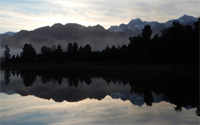
29) Lake Matheson Trail - Fox Glacier Township.
This trail is only 2.6km ( 1.6 miles) roundtrip, but reaches a jetty, where on a clear day, Mt. Cook (New Zealand's highest mountain) is perfectly-reflected in the still surface of Lake Matheson. The trail makes a great dawn hike.
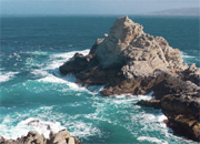
30) Point Lobos, State Natural Reserve, Monterey, California.
There are numerous trails along the Point Lobos area shorelines offering wonderful Pacific coastal scenes. I don't remember any one specific trail that I took, but the entire coast was gorgeous, and any trail within this reserve is a great place to start.
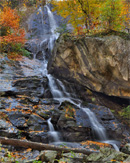
31) Fairy Falls Trail, Yellowstone National Park, Wyoming.
This five-mile roundtrip trail passes through grassland and wooded areas to the 197-foot tall Fairy Falls. It is a pretty easy, flat hike ending at the falls, where you will surely want to hang out for a while, before retracing yor way back to the trailhead.
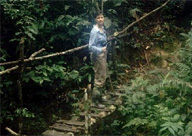
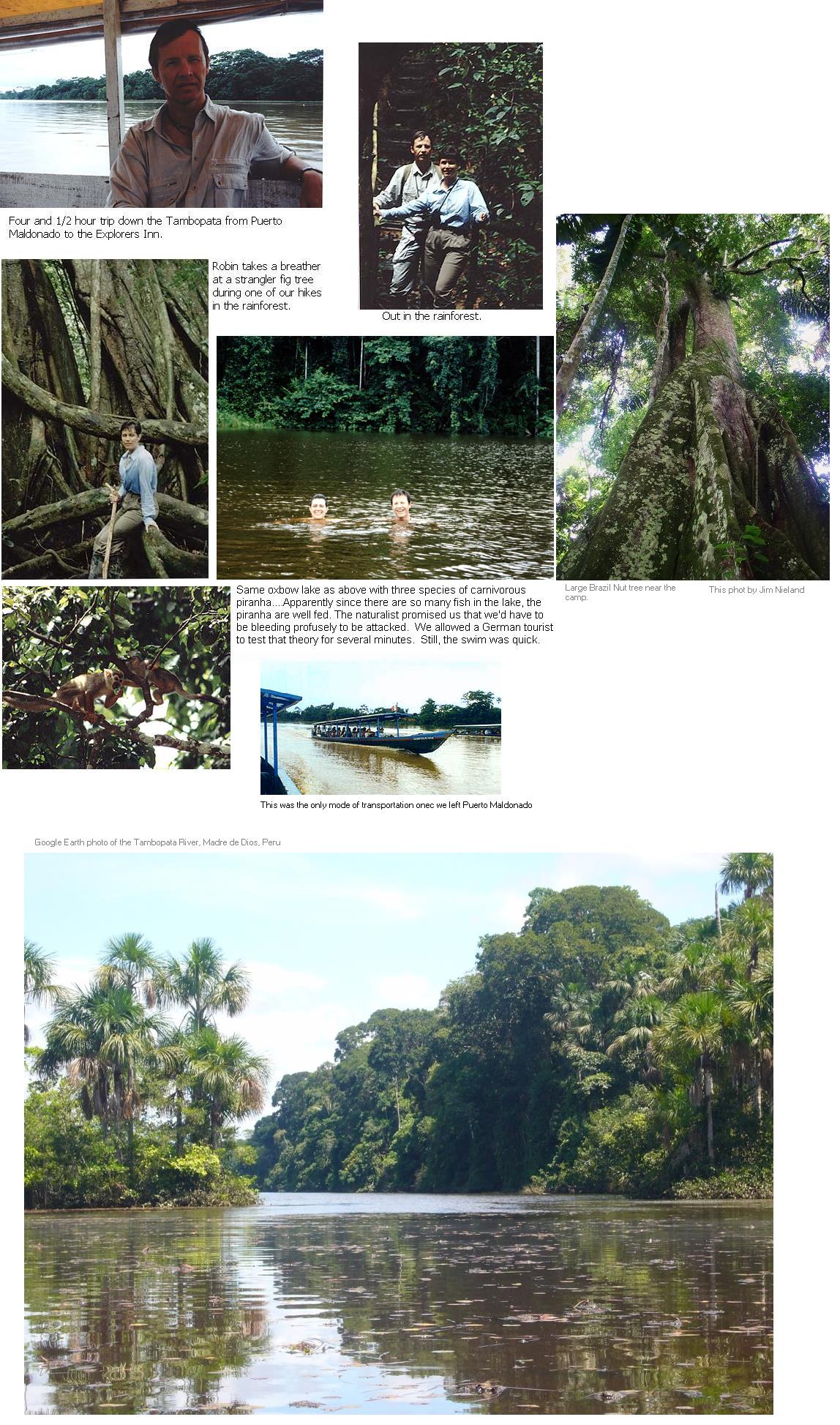
33) Tambopata Wiliderness trails - Madre de Dios Rainforest, Peru.
In 1999, We did a network of short trails around the Explorer's Inn, a secluded, no-electricity, heavily-restricted biosphere camp on the banks of the Tambopata River at the edge of the mostly-uncharted, Madre de Dios virgin rainforest\jungle. Fer-de-lance and bushmaster snakes are common here, sometimes on the trails, as are caiman, candiru parasites, and piranha in the waters. Fresh jaguar prints were found next to the camp's river wharf the morning after our arrival.
Toucan and macaws fly overhead, and monkeys leap through the branches of the high canopy, while various smaller fauna dart across the trails or through the surrounding ground foliage. The trails are muddy (i.e.- tropical "rainforest") and it is entirely nessary to wear "Welties" (Wellington rubber galoshes) to navigate the trails. This is really deep immersion in Nature, and something hard to find outside the Amazon Basin!

34) Outeiro Island Nature Trail - Para, Brazil.
In 1993, I did a nature walk on a trail on this island oustside the city of Bel m, located at the mouth of the Amazon. While we saw no wildlife except a Toucan and a several other bird species, the flora and insects were fascinating and diverse.
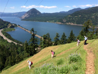
35) Starvation Ridge Trail - Columbia River Gorge, Oregon.
In 2016, We hiked up a very steep, but mercifully short (.5 mile) trail to a beautiful overlook (at approximately 700 feet elevation) of the Columbia River and nearby peaks. The descent was still steep in parts, but leveled off over another 3.5 miles back down to the trailhead. In addition to three waterfalls along this trail, there
is another .25 mile round-trip, level trail, named Starvation Creek Waterfalls Trail, right next to the same parking area, with a very nice waterfall.
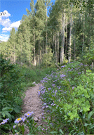
35) Purgatory Creek Trail - Purgatory, Colorado.
In 2021, I hiked this trail, which was one of the prettiest that I have done. Although many sites and guidebooks refer to this popular trail as Purg Flats, do not use that name in your GPS or it will take you to an entirely incorrect location, farther south. Also, the trailhead itself, which lies immediately across US Highway 550 from the main entrance to Purgatory Ski Resort, is labeled on the trailhead sign as Purgatory Creek Trailhead, not Purgatory Flats. The path quickly descends into the Mangas River gorge,
and in early August was filled with a variety of wildflowers, an occasion chipmonk, and was flanked by soaring fir trees, gorgeous aspens, and view of nearby majestic peaks. The trailhead is about 25 miles north of Durango. A round trip down to the river and back up is about six hours, but even an hour hike partially down the trail and a more leisurely return back up is well worth the trip. It is fairly steep, so I'd recommend take your hiking poles.
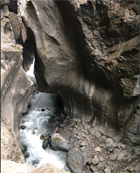
35) Box Canyon Falls Trail - Ouray, Colorado.
This was another 2021 trail I did, which is heavily-trafficked by visitors to Ouray, due to its access right from town. Its is a short set of two trails; one to the high viewing bridge and the other to the waterfall itself. Both are easily fit within a morning or early afternoon, with plenty of time lefy for visiting the nearby Cascade falls, or enjoying Ouray itself.
The lower trail to the falls is pretty easy for almost anyone. The high bridge trail may not be for most older folk or those not up for a steep climb.
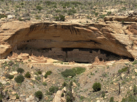
35) Mesa Verde National Park Trails - Mesa Verde National Park trails, Colorado.
There are several hiking trails within the national park, all terminating with impressive views or visits to the park's cliff dwellings, including a hike the Long House viewing point (not down to it), one to to the Step House, and one to Nordeskïold #16 viwing point.
Unless you are able to spend the entire day in the national park, it is doubtful you could do more than one (the Step House, 1-mile) or at most two (Step House and Nordeskïold #16). If you only plan to do abouit 3 hours in the park,
I'd recommend just drivng the Mesa Top Loop Road, stopping at the viewing points and skipping the hikes, because you will spend another hour and a half just driving to and from the park from U.S. Highway 160.
To include the hiking trails requires about anoth hour or more of very winding-and-driving to and from the the trailheads. I arrive at the ark entrace at 8:20 a.m., did all three trails, which added to a bit over 9 miles (approximately 3 hours of hiking),
drove the Mesa Top Loop and stppoed at each of the viewing points, but skipped lunch, did not a lot of time at any of the sites. and wound up leaving the park and reaching the highway again, at about 3:30 p.m. (There are both camping sites and lodges insde the park, but those require advance reservations)
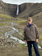
36) Hengifoss Trail - Eastern Iceland.
In 2024, I hiked this trail, which the longest hike that I did while in Iceland. Hengifoss is the tallest water fall in Iceland, and the trail leading to it includes a 980 foot elevation gain. Most sites and guidebooks decribes this an fairly easay trail, but I was 72 years old, and not very aerobically fit. I lected to take my hiking poles, and that helped, especially on the way down, as it started raining and the mixed dirt/gravel tailtrail became a bit slipperry. A few travelers on the trail, dia actually slip and fall, although none were seriously injured.
I took my time on the climb, some of which is better paved, and I stopped to rest, as I felt the need, so it took me approximately and hour and forty-five miutes to reach the trail summit/ turnaround point. I don't have the aerobic issue while hiking downhill, ad with my hiking poles for stability, it only took me about 40 minutes or so to return to the parking lot. most of the onlne photos I've seen show only the flatter areas of the trail, but there are some ealatively steeper areas. The trail's reward is, of course, the stunning 420-foot Hengifoss watterfall, but there also the smaller Litlanesfoss waterfall along the way, as well as some amazing basalt columns in a canyon on the way down, and panoramic views of the
Jokulsargljufur canyon, and the Jökulsá á Fjöllum river.
I suppose there are easily many times more trails that I have done in my lifetime, besides those listed here. I've forgotten the names and exact locations of some of those, such as a half dozen trails used for Volksmarching, while in Germany, and other trails I followed in Switzerland and elsewhere across Europe, within the United States, or even several frequented trails in my home state, Oklahoma. Those listed above are simply the ones which I remember fondly enough to count as favorites. I have not included the many miles walked across various cities, even though sometimes those added up to more miles in a single day than the distances of several of the hiking trails above.

|